Export infrared images when you need copies for presentations, other applications, or further processing. You can create rendered image files, export the temperature values as text, extract associated visual images, or create Radiometric TIFF files for drone mapping. Exporting creates new files and does not replace the source infrared images.
Export images
In Organizer mode, select images in the Folder Contents window. In Analyzer mode, select them in the Image Thumbnails window.
1.Select the infrared images to export.
2.Select Tools > Export ....
3.Choose the destination.
4.Select the required format.
5.Set the available format options.
6.Select Export.
You can also right-click one of the selected images and select Export .... If the selection includes an image stack, each image in the stack is exported as a separate file.
Choose export settings
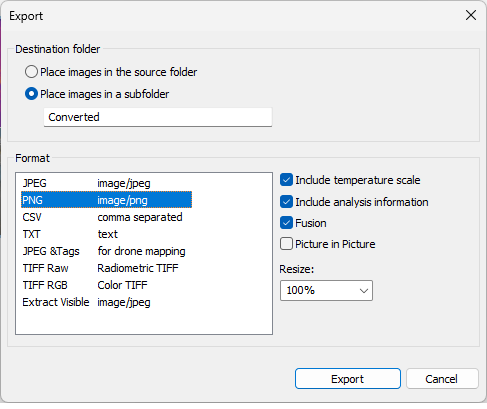
Destination folder
Select Place images in the source folder to save each exported file beside its source image. Select Place images in a subfolder and enter a folder name to keep the exported files separate. IRT Cronista creates the subfolder in the current folder.
Rendered image formats
Select a rendered image format, such as JPEG or PNG, when you need a standard non-radiometric picture. The available formats depend on the image encoders installed with Windows.
For formats that support display options:
§Select the Include temperature scale check box to include the temperature scale.
§Select the Include analysis information check box to include measurement objects and their labels.
§Select the Fusion or Picture in Picture check box to include the corresponding view configured in Analyzer mode.
§Set Resize to change the output dimensions by the selected percentage.
Temperature values in CSV or TXT format
Select CSV or TXT to export the temperature value of every pixel as delimited text. These formats do not include a rendered image, temperature scale, or measurement-object overlays.
Associated visual image
Select Extract Visible to export the visual image associated with each infrared image as a JPEG file. Images without an associated visual image are skipped.
Export Radiometric TIFF files for drone mapping
Availability: Ultimate edition
Use TIFF Raw (Radiometric TIFF) to prepare aerial infrared images for mapping software such as OpenDroneMap or Pix4D. Unlike a color TIFF, a Radiometric TIFF stores the calculated temperature for every pixel. Mapping software can use these values to create an orthomosaic that retains temperature information.
The exported TIFF contains one 32-bit floating-point temperature value in degrees Celsius for each pixel. IRT Cronista calculates the values using the image's current measurement parameters and includes GPS information when it is available. For supported JPEG sources, it also copies available EXIF and XMP metadata.
1.Open the folder that contains the original aerial infrared images.
2.Select the images to convert.
3.Right-click one of the selected images.
4.Select Export ....
5.Select Place images in a subfolder.
6.Enter a subfolder name, such as Tiffs.
7.Select TIFF Raw (Radiometric TIFF).
8.Select Export.
Pix4D: Use a standard processing template for exported Radiometric TIFF files. Do not select the Thermal Camera or ThermoMAP Camera processing template. |
For additional workflow information and current camera examples, see Drone Mapping of Thermal Images on the GRAYESS website.